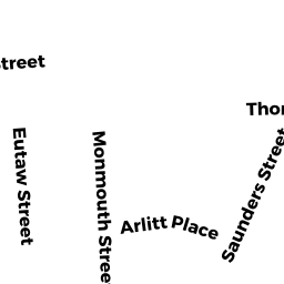
47 EUTAW ST
Owner Information
ORTIZ MARIA
47 EUTAW ST
LAWRENCE, MA 01841


Property Details
47 EUTAW ST is classified as a Multiple Houses on one parcel (Family conver.).
The primary structure on this property was built in 1900. There are 5,620ft2 of built area within this property. There is 3,002ft2 of residential/living space within this property. This property is listed as having 9 rooms.
47 EUTAW ST is valued at $566,000. The land is valued at $137,400 and the structures are valued at $428,600.
This property is in Zone R-3. Confirm with local Zoning Board authorities to ensure there are no overlays or other easements on this property.
The most recent deed for 47 EUTAW ST is recorded at the local registrar in Book 11379, Page 97. 47 EUTAW ST was last sold on Wednesday, November 19, 2008 for $126,000.
Assessment data from fiscal year 2022.
Flood Data
According to the FEMA National Flood Hazard Layer, this property does not appear to be in a flood zone. It may also be in an area not yet reviewed. Nonetheless, confirm this information prior to taking any action.
To view the flood hazards around this property, create a FEMA "Firmette" Map of the area around 47 EUTAW ST.
Broadband Internet Providers
| Provider | Type | Bandwidth (mbps) | |
|---|---|---|---|
| T-Mobile | Fixed Wireless | 25 | 3 |
| Viasat Inc | Satellite | 100 | 3 |
| Verizon New England Inc. | DSL | 10 | 1 |
| HughesNet | Satellite | 25 | 3 |
| Verizon New England Inc. | Fiber | 940 | 880 |
| VSAT Systems, LLC. | Satellite | 2 | 1 |
| GCI Communication Corp. | Satellite | 0 | 0 |
| Comcast | Cable | 1000 | 35 |
Broadband service provider data from December 2020.
Adjacent Properties
- 49A-49B EUTAW ST
Two-Family Residential owned by AQUINO IRENE - 24-26 BUSWELL ST
Two-Family Residential owned by FEDERAL NATIONAL MTG ASSOC - 42-48 MONMOUTH ST
Two-Family Residential owned by CONTRERAS WENDY - 34 - 36 MONMOUTH ST
Three-Family Residential owned by SANTOS MILQUICIDED - 45 EUTAW ST
Single Family Residential owned by PROVOST THERESA